About Us

Welcome to our blog of our 2013 trip. We Have been camping since our honeymoon. Each summer we take a trip to a new part of our country. We try to stop at local fairs & festivals, take tours of manufacturing plants, do a little kayaking, and try to get an up close look at how people live! Join us! This Bog runs from our most recent post backwards. At the end of this year,I have left the past years blog. Double click on any picture to get a larger image. These are all low res versions. If you see one you really like, let me know and I'll send you a better image.

Liz & Bruce on the way to Minnesota, last year

Wednesday, July 28, 2010

Saturday July 24

We decided we wanted to tour the Quincy copper mine back in Hancock, one of the towns we came through to to get to Copper Harbor, so Saturday morning we went down to a Hancock city park, to tour one of the areas great copper mines. This was restored by a co-operative effort of a local group of towns people and the National Park Service. We went on a ranger led tour of the above ground ruins and facilities that have been restored.
Copper is found in this area in deposits called "floats" that are simply areas where copper has been gathered together, back in time, under ground and due to changes in heat and pressure gets forced through holes in rock. These floats are essentially pure copper, but can not be mined! Because copper is so ductile, they need to have it mixed in with other rock so that it can be broken off and hauled out. This results in mountains of tailings. There were an number of interesitng buildings in process of being restored, including the original hoist. This enormous device was used to transport men down to the mine, and copper out. Imagine the drum you see here wrapped with miles of cable. The mine had dozens of levels, and the operator controlled it all from a small station above and behind this drum The drum was operated by steam. The cable was connected over towers to cars in the mine shaft. The shaft went into the ground at the same angle as the roof line in the photo, left. Next we went on a mine tour. We donned coats and hardhats and climbed in a cog rail car and went down a very steep slope to the bottom, just before the bridge in the photo, right. We transferred to a trolley that took us into the mine. There a gujide took us around and showed us how miners used to come down with a candle for illumination, and in small groups of two or three, would drill, blast, and haul out rock that contained a relatively small percent of copper ore. The chart you see is the map for all of the veins that Quincy was mining. The mine was very wet and reasonably cold, about 40 F. We were told that prior to the hoist, the miners would have to descend into the mine each day on ladders - and after working 12 hr shifts climb back out on ladders. Surprisingly in the 40 or more years Qunicy mined this shaft only about 250 miners lost their lives.

Sunday, July 25, 2010

Friday July 23

Friday morning we decided to go kayaking. We put in first in Lake Fanny Hooe, a small lake that is right in the center of the tip of the Keewanah. It had a stream that ran thru to to Superior, so we figured that would be a good access point. When we got out there we found the stream was way to small, even for kayaks so we paddled back threw the kayak's back in the truck, and went to the big lake. We had a great time, and proceeded to paddle out around the lighthouse.
When we made the turn around the point you see in the picture, I looked down, in water that -by kyak paddle measure - was well deeper than 4', and saw veins of copper and quartz running through the rock on the lake floor! We both shouted out at the same time!
We then learned quickly how fast the weather changes on Lake Superior! Again at about the same time, we both felt the wind change and become offshore, blowing us out in the lake! That ended our excursion for the day, and left us a long paddle back into the wind to the truck. Great fun.

Later that afternoon we took a walk through the fort. It is staffed by students from area universities acting the role of Army staff and family in the late 1800's. They did a good job of depicting the life in a fort of this type. Ft. Wilkens was not a Protection garrison for the country, but kind of a "peace keeping" garrison to maintain order among the prospectors. It was staffed for a few years, abandoned, then staffed again. Not the difference on the joint technique in the two buildings.
A little later we went down Brockway Dr. an old road that runs down the "spine" of the peninsula. It takes you to the highest peak between the Alleghenies and the Rocky's, 1328'. It was beautiful. In the photograph, you can see Lake Superior on your left, the village of Copper Harbor, and Lake Fanny Hooe on your right. The fort and our campground is right between them, hidden by the trees. Our canoe route is out around the lighthouse you can just see on the left. Look closely, and you'll see the Lake is now in whitecaps, and it only got rougher!
In this photo you may notice some notably taller trees sticking up out of the other forest. These are the virgin growth trees we saw yesterday. When we got to the top, there was a sign and a single lonely souvenir stand. What a view of Lake Superior however!

Wednesday & Thursday July 21 & 22


Wednesday morning Bruce and I woke to the first clear morning we had seen in Munising. It was beautiful to look out over Lake Superior as we left for Copper Harbor up in the Keweenaw Peninsula of the U.P. We stopped in Marquette, MI to check out the Marquette Harbor Light and then headed further west.


Our next stop was at the Da Yoopers Tourist Trap. I must explain that most people who live in the UP, refer to themselves as Yoopers, believe that the U.P. should be the fifty-first state, separate from the lower peninsula of Michigan. Believe me, it is worlds apart from the rest of the state. At any rate, we had to stop at the Yoopers Tourist Trap. Most of the stuff was the typical tourist trap kitsch, tailored to the U.P. There were lots of silly items based on tacky jokes. Keeping to its name, it had lots of “interesting” items out along the road. Bruce will include some self-explanatory photos. It was a kick.
The Gun really fires a projectile, using propane!
We continued across the U.P. and through a couple of pretty upscale towns, Houghton and Hancock, mirroring each other along the Portage Lake and Portage River. Calumet was the only other town of any consequence after that. As we traveled up US Route 41 there were a number of little towns that amounted to junctions in the road occurring occasionally. Otherwise, there was woods, for miles.
US Route 41 runs from Miami, FL up to Copper Harbor, MI. The length is approximately 2000 miles and it runs through seven states. I would imagine a lot of it resembles our Route 9 in CT – four lanes, limited access, etc. The part of US 41 we were driving on was two lanes of tar and chip and although I am sure this road sees its share of RVs, it probably hasn’t seen anything as tall as an eighteen wheeler in years. The trees felt like they were going to hit the top of the trailer. We traveled on this winding, tunnel-like road for what seemed like forever, but it was really only about ten miles, before reaching Copper Harbor.
Bruce tells me that Copper Harbor has 75 full time residents. Tourism is a significant chunk of their economy up here, but from what I can see, there currently appears to be only a hundred or so folks in town. It is a cute, touristy town on the very end of a small peninsula off the northern shore of the U. P. of Michigan, jutting out into Lake Superior. Looking out at the water, it is so vast you would think you are looking out over an ocean. There are the requisite gift shops, restaurants, motels that look like they’re out of the 50s, a couple of general stores and a passenger ferry that will take you the fifty miles over to Isle Royale, a mostly wooded island in Lake Superior, that is particularly popular with hikers and primitive campers.
If you continue through town you will arrive at Fort Wilkins State Park. That’s where we’re spending Wednesday, Thursday, and Friday night. It was an Army fort that was established to keep the peace in copper country in 1844. It was not long in active use and became part of the state park program in 1923. The fort was rehabbed in the 1930s under the Work Project Administration. During summer months it has interpreters to educate visitors about the fort. On the property are two campgrounds done to usual Michigan park standards: nicely wooded, clean, well maintained, electric on site, shower house and laundry nearby. There are a lot of empty sites, but people are starting to arrive now that the weekend is approaching. Considering the distance from the “real world,” I don’t imagine they get too many weekend campers up here. They will probably be full next weekend because they are having a Civil War encampment. It’s too bad we’ll miss it.
Thursday, Bruce and I went out to wander and to see if we could get a cell phone signal. We drove down the northern coastline of the peninsula to see the Eagle Harbor lighthouse. The Marquette, Copper Harbor and Eagle Harbor lights are all rather small lighthouses compared to those we’re more familiar with down in Hatteras. They consist of a light tower that is only a bit higher than the adjoining building structure and are very quaint in appearance.
Driving a bit further, we came to a beautiful monastery called the Holy Transfiguration Skete, of the Society of Saint John. The monks make baked goods, and jams and jellies from locally picked fruit. All to support the monastery. The order, at least at this location, has existed for 25 years, but seven years ago built a lovely monastery. It sits immediately on the coast and is probably the most beautiful manmade sight on the peninsula. The gardens of flowers were obviously tended with devotion. We stopped to get a few jars of goodies and some delicious spice cookies to munch on as we drove.
We stopped several times at little roadside parks…rocky beaches, all extremely picturesque. Michigan has the best roadside parks we've seen. Most are small little turnoffs, with a picnic table, fire pit and a great view. They are scattered all over the state, on small two lane roads such as US 41, as well as Michigan's state highway system.
Liz had found a virgin growth forest, Estivant Pines, so we took a hike through it. There were a number of magnifiant old trees, mixed with a lot of younger trees. From the picture you can see a section of a tree that was alive when Columbus came to America in 1500! The trees were big, but because of the cold winters and tough environment, they don't grow as big around as the Calif. redwoods. The older trees were mostly white pines, but hthere were a few virgin growth hardwoods such as oak in the mix.

Tuesday, July 20, 2010

Monday & Tuesday July 19 & 20 Painted Rocks MI


Shipwreck Tour

Because we heard there was a chance of scattered thundershowers Monday, we did two different boat cruises out of Munising Monday. The first was on a shipwreck tour in a glass bottomed boat to look down through the water at some of the old wooden wrecks here in the bay. These are apparently very popular for divers to explore because of their accessibility. These wrecks sit in an area called the Alger Underwater Preserve, which means that besides being of historic value, they are protected. One can be prosecuted for damaging or removing any part of the wrecks. The water is so clear you can see down quite some distance. On our way out to the sites of the wrecks the narrator pointed out local landmarks including the picturesque, but non-operative East Channel Lighthouse at the southeastern end of Grand Island. We see the southwestern corner of Grand Island from our campsite. There was a bald eagle posing in the top of a tree nearby. Eagles are numerous in this area.

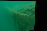
When we got to the first site, they lifted the seats covering two viewing wells and we could see the wreck of the Bermuda quite clearly through the polycarbonate windows in the bottom of the boat. The narrator said the tallest parts of the wreck were about six feet under water. The captain was able, through the use of two electric motors, to keep us hovering above the wreck, moving back and forth and up and down along the 150 feet of the wooden hulled schooner. It is said that she was carrying iron ore and probably wrecked sometime in the mid-1880s. It was amazing to see how intact the body of the boat was. A recovery company won the rights to reclaim the valuable ore aboard and broke open the top of the hull to get it out, but other than that, she seemed in pretty sound shape. The wood has all been preserved by the cold water, and the fact that the Bay has three feet of ice on it every winter. We were told that any valuable parts of the rigging had been retrieved shortly after her sinking to be used on another boat.

Since we were in relatively shallow water, you could see the bottom as we moved to the next site. It made you kind of dizzy to watch it go by so quickly, though. The next ship we saw was the Herman Hettler. She was a 210 foot wooden steamer that sank in November 1926. You could see parts of her scattered all around because she hit a rock reef and sank only partially. She was considered a navigation hazard, so she was dynamited by the Coast Guard and her remains rest in about 25 feet of water. You can see various parts of the bottom structure of the ship itself and other items such as the anchor and long bolts that were used to keep various pieces tightened together. Also visible were the Captain’s white porcelain toilet and claw foot bathtub with two huge boulders sitting in it.

The third remains we saw were of an unidentified ship they called a scow-schooner. Again, you could see many large chunks of the well preserved bottom of the boat. They said it was not well designed for use on the lakes due to the flatter bottom. It wasn’t constructed to handle the wave action here on Lake Superior. The trip was quite interesting and not at all eerie like I thought it would be.

Pictured Rocks National Seashore

The second cruise of the day was to take a twilight cruise of the Pictured Rocks National Seashore. I am not sure that words can adequately describe the three and a half hour trip we took out of Munising Harbor, but I shall give it a shot. It looked threatening as we headed over to the cruise, but Bruce had
re-checked the weather report and it still looked like it would hold. We dressed in fleece and hoodies and I grabbed my umbrella as I left the truck. It was drizzling when we boarded the boat and we were hoping it would stop. After some seat shifting for people who went downstairs to be under cover, Bruce and I scored front row seats. And, to our good fortune, shortly thereafter the rain ceased. It was beautiful the rest of the evening and it was topped off by a beautiful sunset on the return trip.

The brochure advertises this cruise as being “voted #1 Boat Cruise in Michigan” by Michigan Living and AAA Magazine. It invites you to “Come join us for an adventure you’ll never forget!” For once, something lived up to the advertising – even surpassed it. Pictured Rocks National Lakeshore is a park that is only three miles wide, but 40 miles long. It gets its name from the sandstone cliffs that rise out of Lake Superior and are seemingly painted a multitude of colors by various minerals contained in the water that seeps through between the rock layers. Added to this is the strange way the various rock layers have been eroded by ground water and the waves into caves, arches, columns, and coves. The combination of shapes, colors and the evening light was spectacular! Mother Nature is such an artist! Bruce will add some photos, but I am not sure even photos can adequately represent what we saw. I would highly recommend this trip, if you get the chance. It is worth the trip to the U.P.

The next few pictures need explanation. The first is a lone pine tree perched on a rock. Look closely and you'll see it's root system goes from the tree, left to the shore.The tree was growing on shore and over time the rock around it was eroded away, in Lake Superior's violent winters, leaving this tree on a thinly soil covered "island". To survive it had to grow an anchor to shore and nutrients, amazing.

The next show our boat heading into a narrow opening carved into the shore. The radar dome is ahead of me, and the pole is on the bow. We continued in, until we were actually under the ground above us. I looked up and shot this picture, on my left is the radar and way under the rocks is the bow marker pole. The last shows us backing out, with the passengers still amazed by what we had just experienced!

On the return trip, the light conditions had changed markedly and Bruce was able to capture different features. Soon however, it got too dark to take many pictures of the rocks and our attention turned to the sunset. As we have mentioned before, the sun doesn’t set here until about 9:30, so we had a long relaxing ride back snapping sunset pictures or just relaxing and enjoying the view.


Bruce and I decided after such a busy day yesterday to take it easy Tuesday. So we’re sitting here under our awning looking out the west channel of Munising Bay in Munising, MI. The bay opens into Lake Superior only a few miles out. We’re watching the seagulls challenge each other for perching rights in some sort of berry bush at the edge of the beach. Maybe we should check out the berries. The gulls apparently find them worth squawking and shoving over. The birds are so heavy on the flimsy twigs that they can’t settle on them and must continue to flap to support themselves. No matter where they are, it seems seagulls are always entertaining. The weather here is sunny, with some scattered clouds, and 75 degrees with a stiff breeze from the west. Our day’s activities will include catching up on the blog while we have internet, some basic food prep so I can get meals ready with less fuss and maybe some laundry, although a bit later we might be inclined to carry the kayaks over to the beach and go for a paddle. It’s tough, but somebody’s got to do it! We're staying in municipal park here in Munising. Before you start thinking cannons, statues and pigeons, they are different out here. We've stayed in several during our travels, and we have never been disappointed.

(Before posting, we actually went up to an observation position over the bay, and a thunderstorm rolled in. I’d forgotten how vicious thunderstorms can be out here in the Midwest – WOW. Thanks Liz for preparing this one. Tomorrow, We are leaving the relatively unpopulated part of the UP and heading to country where no-one has cell service or internet- NO-ONE, bye bye!BWB)

Saturday, & Sunday, July 17&18 Taqhamanon


Saturday morning we had a pretty fair drive down along the Trans-Canada highway to Sault St. Marie and back to the US. Once in the US we had about 1 ½ hours to Taqahmanon Falls State Park, home of Michigan's highest falls. Our GPS said ~5 hrs, my mapping program, with stops and accommodations for pulling the trailer, said longer. We were out around 8:00 , and the road was beautiful, although just 2 lane the whole way. Both the condition, and once we left the Sudbury basin, the scenery. We made good time to the US border, and found the approach to be right thru downtown Sault St. Marie! Right turn, left turn, etc. Not what I was expecting. The line at the border was long, to the top of the bridge. I had to choose a lane – and picked the slower one. Then customs agent asked us about fruit and veggies, and we had everything he asked about in the fridge. In the end we only lost our peppers, because, while we bought them in Canada, they were imported from Holland. Go figure!

We got to Taqahmanon Falls about 5:00, and found there was a 7:30 wolf program. Beautiful pull thru site, electricity, and around $20. We quickly set up ate and went.

Wolves are a favorite of ours since our first trip to Algonquin. There they had a “Wolf Howl”, where a ranger imitates a wolf cry, and you can hear them answer. It wasn't the right time of year this year in Algonquin, and we knew this wouldn't be that program, but it was good. We had a nice walk in the woods along the Taqhamanon river channel, dug back in logging days to get the logs around the falls. We had a chance to feel their pelts, plus those of some of their cousins, coyote and fox. We herd about their habits and saw their favorite winter feeding grounds, a beaver habitat. Good interpretive program.

We discovered in their park newspaper, that Micigan state parks are not funded by state taxes! They are totally funded by user fees! This amazed us, because of the reasonable camping fees, and the superb features and condition of their parks, even up here in the sparsely populated UP. They do charge an annual park fee of ~$20 for residents which allows entry in all parks. You see it on almost every car. What a deal!

On Sunday we, or the park got our schedules wrong, because despite verifying the location of the guided tour of the falls twice, we showed up at the lower falls, when the program was at the upper falls. Oh Well. The lower falls is not as dramatic, but you can boat right up to it, and they rent rowboats reasonably to facilitate it. It began to rain lightly, so we left and went to the upper falls. We had already left our campsite, but they had plenty of space in the parking lots for us.

The upper falls is about 200' long, and about 50' high, at a glance it looked like a mini Niagara. Besides size, one difference, the water was brown. We thought iron at first, but it is actually tannin from the roots and decaying hemlock trees the entire area is forested with. We opted for the 110+ step down boardwalk along the river up to a nice viewing angle. No boats here, just a nice walk, in the light rain. We did find out from the signs that the area was heavily logged of white pine in the late 1800's. Seemed like the same conditions as Algonquin's later logging. There were many local sawmills. And Lake Superior for shipping to the Great Lakes region. We left for a relatively short 2 hour trip to Munising, home of the painted rocks.

A note about logistics. Generally we like to travel about2-4 hours on our moving days. Then we spend 2-3 nights in a location, depending on things to do in the area, and the distance to travel to them. Think of our trips as a string of weekends put back to back across an area, with a few of them holiday weekends. We don't fuss much about food, although those of you who know Liz well, know that I don't lack for new and interested things to eat. We like to try the local fare if it is different, especially for lunch. On this trip we have not eaten out, mostly for lack of opportunity. This area is known for Pasties (short a folks), kind of a folded pot pie, that the men building the Mackinac bridge ate for lunch. We'll eat out more often on the later part of the trip we suspect. No TV, no radio, XM and CD's mostly. We didn't know the “hole was plugged” in the Gulf, until a ranger mentioned it in a program. This year is different, because I'm actively seeking Internet access to post on this blog. Otherwise we probably wouldn't connect often, at least until my new students start emailing me, closer to the end. We're no on a mission to leave the world behind, we just loose interest in that presentation, I guess. We like to see what others think.